Cairngaver - 214m, 1 point
Association: Northern Ireland Region: Mourne Mountains
Latitude: 54 36 56 N, Longitude: 5 45 0 W
Grid Reference: J 454765, QTH Locator: IO74CO
This summit is a bit of an outlier, not really fitting into any other region, it's been tied in with the Mourne mountains. The Mournes it definitely is not, but it was a convenient place to grab a quick activation after leaving my mum to do some shopping in nearby Hollywood.
We parked on the farm track leading to the hill. It would be possible to drive virtually to the top but fancied a walk in the glorious sunshine. Only a mile each way with about 150' of ascent.
 |
| Short walk |
 |
| Approach road |
 |
| Summit |
The views here are quite spectacular. The Antrim Hills are visible to the north; to the east, looking out over the Irish Sea, the Scottish coast is visible and to the north the Mournes are visible on the skyline. To the west there are great views over Belfast and the hills further out.
 |
| Looking east. Copeland Island and Scottish coast in distance |
 |
| Scrabo Tower and Strangford Lough |
 |
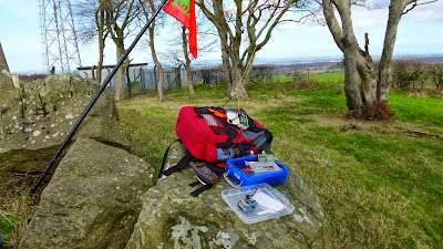
| The shack |
QSO map from Log2map by ON6ZQ
As we were packing up we were surprised to see a herd of cattle passing the fence in the adjacent field. They followed a winding path and started to descend the hill to the east. As the front runners disappeared form view, the tail enders were still not in view. We sat for about 10 minutes watching the procession and it never ended! We estimated at least 500 cows had already passed us by the time we left and there appeared to be no end in sight.
 |
| Never ending cattle train |
Another warm sunny day, followed by a quick run to Ikea for a coffee and a bit of plane spotting.
Excellent.


No comments:
Post a Comment