Sunday, 22 March 2015

SOTA - Slieveanorra - GI/AH-003


Slieveanorra - 508m, 4 points

Association: Northern Ireland Region: Antrim Hills
Latitude: 55 4 25 N, Longitude: 6 13 31 W
Grid Reference: D 134266, QTH Locator: IO65VB


After Trostan, I made my way the short distance to the access road for Slieveanorra. There were 2 cars already parked in the gateway, but there was plenty of room to accommodate me and a few others.
Parking spot
This was a pleasant and easy ascent, initially through a forested area, before opening up to barren moorland. There were no bogs to contend with this time! There is a wide gravel path all the way to the summit.

Route

Through the forest

Gravel track to summit
Never far from the Moyle Way

Near the top there is a memorial plaque and information board relating to a crashed USAAF, B17 Flying Fortress, lost in 1942. It was here that I met the only two other hikers I'd see all day.


There's a stone summit shelter at the top, but I decided it was more sheltered tucked in behind the transmitter building. It was still blowing a gale, although a lot warmer than the early morning activation.


The shack.
 A quick set up and I was ready to operate with great views across to the distinctive summit of Knocklayd (AH-002) and the cliffs of  Rathlin Island beyond.

Knocklayd and Rathlin in the distance

Conditions were down, compared to the morning, with 40 QSO's including  3 nice S2Ss with LX/G4OBK/p on LX/LX-002, EA1AER/p on EA1/LA-098 and G4RQJ/p on G/NP-015.
QSO map from Log2Map by ON6ZQ.

The activation concluded when the guying ring on my mast broke bringing the antenna tumbling to the ground! It had been punished enough for one day in the strong winds.
An easy descent, and then rush home for Sunday dinner, to bring my little GI visit to a finish,
once again blessed with beautiful sunny days.
I'll be back to finish off the three remaining GI/AH region summits and then concentrate on the Mourne Mountains.

SOTA - Trostan - GI/AH-001


Trostan - 550m, 4 points

Association: Northern Ireland Region: Antrim Hills
Latitude: 55 2 44 N, Longitude: 6 9 22 W
Grid Reference: D 179235, QTH Locator: IO65WB


Heading north again, what better way to spend a sunny Sunday morning than on Antrim's highest point, Trostan. I decided to approach this one from the west so that it would be a short drive afterwards to Slieveanorra, GI/AH-003.

The route from the west.
Parking spot by Moyle Way.
 I found the parking spot by the Moyle Way easily enough. There's room for about 3 cars here but I was alone on a pretty desolate country road.

This way...
I booted up and added an extra layer as, although bright and sunny, it was decidedly cool in the fierce wind.
Trostan  - this way.
I headed for the footbridge which crosses a small stream and before I'd reached it the peat bog had already swallowed my boots on several occasions. The going did not get any easier. This was one huge bog and I regretted not bringing gaiters along with me on the trip. I was soon up to my knees in glop and so it continued as I climbed. The ascent is approx 860' over  1.8 miles and relatively easy going in most places. Towards the top I was confronted by a wire fence. Finding no style, I just decided to scale it and head directly for the summit. Once on the summit plateau the terrain changes completely. It's  a dry and stoney and a bit "Lunar" like. 

Summit with Slieveanorra in the distance
The wind was now very cold and strong, so I setup shop in the lee of the summit mound. The pegs for my pole were finding it tough getting purchase in the sandy surface so I had to supplement them with some extra rocks.

The shack
Just as I set up, three fell runners arrived and very quickly beat a retreat back down again.
HF conditions were pretty marginal with 54 QSOs achieved. Unfortunately no S2S on this one and lack of mobile signal meant checking online was not an option. 


With an hour on the summit being blasted, I'd had enough and quickly packed and started the descent. This time I looped around the fence line, a longer route, but eventually picked up the marker posts for the Moyle Way again. The swamp did not improve any and I arrived back at the start rather dirtier and wetter than when I'd left a few hours earlier! Still the sun was shining and  Slieveanorra was calling..

The bog won...


Saturday, 21 March 2015

SOTA - Cairngaver - GI/MM-017


Cairngaver - 214m, 1 point

Association: Northern Ireland Region: Mourne Mountains
Latitude: 54 36 56 N, Longitude: 5 45 0 W
Grid Reference: J 454765, QTH Locator: IO74CO


This summit is a bit of an outlier, not really fitting into any other region, it's been tied in with the Mourne mountains. The Mournes it definitely is not, but it was a convenient place to grab a quick activation after leaving my mum to do some shopping in nearby Hollywood.

We parked on the farm track leading to the hill. It would be possible to drive virtually to the top but fancied a walk in the glorious sunshine. Only a mile each way with about 150' of ascent.

Short walk


Approach road
The summit itself is on a small elevated mound surrounded with trees and convenient operating rocks next to the trig point.

Summit
The views here are quite spectacular. The Antrim Hills are visible to the north; to the east, looking out over the Irish Sea, the Scottish coast is visible and to the north the Mournes are visible on the skyline. To the west there are great views over Belfast and the hills further out.

Looking east. Copeland Island and Scottish coast in distance

Scrabo Tower and Strangford Lough
 Conditions had taken a bit of a dive again due to yet more auroral activity overnight, however first in the log was Nick, ON/G4OOE/p on ON/ON-021 for the first S2S of the day. This was followed by a steady stream of chasers to make 38 QSOs including another S2S with OM3CUG/p on OM/ZA-116.

The shack

QSO map from Log2map by ON6ZQ


 As we were packing up we were surprised to see a herd of cattle passing the fence in the adjacent field. They followed a winding path and started to descend the hill to the east. As the front runners disappeared form view, the tail enders were still not in view. We sat for about 10 minutes watching the procession and it never ended! We estimated at least 500 cows had already passed us by the time we left and there appeared to be no end in sight.

Never ending cattle train

Another warm sunny day, followed by a quick run to Ikea for a coffee and a bit of plane spotting.
Excellent.

Thursday, 19 March 2015

SOTA - Slieve Gullion - GI/CA-001


Slieve Gullion - 576m, 4 points

Association: Northern Ireland Region: County Armagh
Latitude: 54 7 17 N, Longitude: 6 26 4 W
Grid Reference: J 024203, QTH Locator: IO64SC


Well it being my Birthday, I had a choice of how I wanted to spend the day! Initially I had thoughts of a long day in the Mournes, but inspired by the recent BBC documentary,
Ar Scáth na Sléibhte, I decided to go to an area, virtually unknown to me, and activate Slieve Gullion.
Once again the NI weather was kind, warm, sunny and bright, so yet another day in shorts.
The Southern access road to Gullion was closed so we (my sister joined me) decided on a route from the North starting on a minor road. Google seemed to suggest there was room for a few cars, and when we arrived we found that to be the case. 

Parking spot.
The track was easy to follow on the ground and there were regular iron waymarkers. I followed a GPS route following the path marked on Open Street Maps (which I find quite superb).

Waymarker

A steady climb
The climb was fairly straightforward with only a few short sharp bits to contend with. Generally it was pretty dry underfoot with only the occasional boggy patch. The ascent was just a fraction over 2 miles with approx 1000' of altitude gain.

The route
Near the summit there is a mountain top lake, The Lake of Sorrows, steeped in Irish folklore.
Aparently this is where Cailleach Beara, the unspeakably wicked witch, turned the mighty hero, Fionn MacCumhaill, into a feeble old man when he dived into the Lake of Sorrows to retrieve her golden ring.


No bites...
I'm often asked when out walking why I'm carrying a fishing pole. Well today I had a real answer...

Lake of Sorrow

Slieve Gullion summit cairn in the distance
At the summit there is a cairn which is an ancient passage grave.

The summit cairn

Entrance to Passage Grave

Inside the grave
After a picnic lunch in the sunshine, it was time for the activation to begin. I picked a spot out of the wind in the lee of the cairn.

The shack

Operating in the lee of the cairn
Conditions were again pretty good with a total of 54 QSOs spread from East Coast USA to Asiatic Russia in the east. Only a single S2S today with HB9CBR/p on HB/NW-017.

Birthday activation.
It was soon time to pack and head homewards. I did have a Birthday party to attend :-)

We saw only four other people very briefly at the summit. The sun shone and the weather and propagation gods were kind as usual.

Now for a beer or two...


Wednesday, 18 March 2015

SOTA - Big Collin - GI/AH-008


Big Collin - 353m, 1 point

Association: Northern Ireland Region: Antrim Hills
Latitude: 54 48 7 N, Longitude: 6 5 6 W
Grid Reference: J 232966, QTH Locator: IO64WT


Big Colin is another old stamping ground for me. Many years ago we used to fly model gliders from here, it being a popular slope soaring site. The last time I was here was in 1979. Needless to say it's changed a bit. My regular ascent route is from a small carpark on Collin Road. Attempts to reach this were however scuppered as Collin Road was closed for resurfacing. I ended up finding a space to park next to a farm on Tildarg Road, very close to the wind farm.

The route through the wind farm.
 This proved to be a good spot, although a longer walk in than from the northern car park. Round trip was 3.2 miles with approx only 400' of ascent.

The wind farm was totally new to me. It wasn't here in the 70s! It amused me to see the speed limit of 19mph. EU bureaucracy gone mad...

 Wolf Bog - 19mph!
It was an easy walk on the surfaced track up to the highest turbine, then it was a short dart across open boggy land to the elevated summit mound. This has a slight depression which makes for a nice place to sit. 

Summit in the distance to the right of the far right turbine

The unmistakable "Slemish" GI/AH-007 in the distance

Summit, possibly a burial chamber?

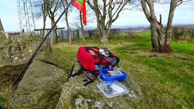
The shack looking south.

Sunset on the descent

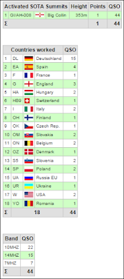
Conditions again were far better than I ever dreamed. 44 QSOs with 2 Stateside callers in the shape of W0RW and once again N4EX. Two spanish S2S rounded off the day with EA2BD/p on EA/NV-089 and EA2CW/p on EA/BI-076.


The temperature dropped quickly as the sun set behind the wind turbines, so it was a quick descent and then back home for some dinner. 
A great days activating and as usual wall to wall Ulster sunshine.