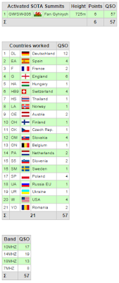
Association: Wales Region: South Wales
Latitude: 51 51 33 N, Longitude: 3 37 35 W
Grid Reference: SN 881191, QTH Locator: IO81EU
It took me just over an hour to hike the 3 miles between summits of Fan Nedd and Fan Gyhirych with approx 800' ascent from the connecting coll.
 |
| Looking back up to Fan Nedd |
 |
| Today's elevation profile. |
 |
| Walking along the ridge of Fan Gyhirych |
Part of the route between summits is a wide stone track. It's rare to see anyone on this summit and today was no exception except for the surprise of meeting a tractor pulling a trailer with a JCB on the back. What was more surprising was that the driver was eating, what looked like his evening meal, as he drove along...
With a strong wind still blowing, it was definitely time for the tarp again. It was a bit cooler on this summit as I now had to sit in the shade to stay out of the wind. Even though it was beautifully sunny, I had 3 layers on whilst operating.
 |
| Shack with a view |
 |
| In the shade |
Conditions were good and this time around 57 QSOs in the log. S2Ss with HB9CGA/p on HB/ZH-008 and DL/HB9AGO/p on DM/BW-157 rounded of the activation for the day.
QSO map from Log2Map by ON6ZQ
 |
| The track home. |
After an hour it was time to pack up and make my way back to the start. This time I contoured round the bottom of Fan Nedd.
Total distance for the day was 7.5 miles and 1820' ascent.
A lovely day out in GW and one of my favourite double activations.


No comments:
Post a Comment